Nova Pacific Drills 11 m @ 1.8 g/t AuEq at Lara VMS Project on Vancouver Island, B.C. with 29 Holes Pending
Vancouver, British Columbia–(Newsfile Corp. – July 15, 2025) – Nova Pacific Metals Corp. (CSE: NVPC) (OTCQB: NVPCF) (FSE: YQ10) (WKN: A40GFH) (“Nova Pacific” or the “Company“) is pleased to report assays from three additional drillholes totalling 681 metres from the Company’s recently completed 8,660-metre exploration drilling campaign at the Coronation area of its Lara VMS Project on Vancouver Island. The Lara Project spans a 17-km belt of the McLaughlin Ridge Formation, which is correlative with the volcanic package that hosts the past-producing Myra Falls VMS Mine, 140 km to the northwest.
Highlights:
-
Hole NP25-005 intersected:
-
11 m grading 1.8 g/t AuEq or 4.3% ZnEq (1.1 g/t Au, 0.55% Zn, 17.8 g/t Ag, 0.26% Cu, 0.18% Pb) from 135 m downhole
-
8.33 m grading 1.0 g/t AuEq or 2.3% ZnEq (0.8 g/t Au, 13.4 g/t Ag) from 80 m downhole
-
1 m grading 2.7 g/t AuEq or 6.9% ZnEq (1.2 g/t Au, 1.76% Zn, 61 g/t Ag, 0.08% Cu, 0.95% Pb) from 89 m downhole
-
(All intervals are down-hole lengths. True width estimated at 87% based upon historical data. AuEq and ZnEq are provided for illustrative purposes only. See Table 1, footnote 4 for calculation parameters)
-
Assays from 29 drillholes remain pending
-
Drilling has concluded with a total of 8,660 m over 41 drill holes
-
Mineral resource estimate targeted for Q4/2025
“We continue to be encouraged by these early results, which align with our exploration model and appear to expand mineralization in a key area of the Coronation zone,” commented Sam Eskandari, Nova Pacific’s CEO. “With results pending from 29 additional drillholes, we look forward to steady news flow as we advance toward a current mineral resource estimate targeted for later this year.”
29 Drillholes Remain Pending from Phase 1 Program
Nova Pacific has completed its Phase 1 drill program at the Coronation area, with 41 holes drilled totalling 8,660 m. Of these, 36 holes were completed, while five were abandoned due to challenging conditions. To date, results from 7 holes have been reported and results from 29 drillholes remain to be reported.
Results Continue to Support Exploration Model
The drillholes reported in this release, summarized in Table 1, are located near the northwestern end of the 1.5 km Coronation trend outlined by historical drilling. The following disclosure provides context on the objectives and results for each hole within this target area.
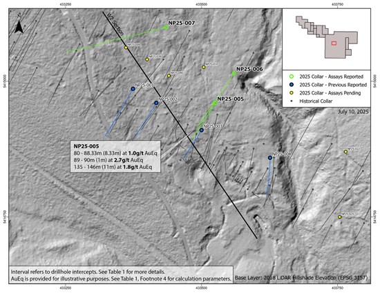
Drillholes NP25-005 and NP25-006 were designed to test down-dip and down-plunge extensions at the northwestern end of the 1.5 km Coronation trend outlined by historical drilling. NP25-005 intersected 8.33 metres of the Hanging Wall (“HW”) zone from 73.67 metres downhole at a location consistent with the Company’s exploration model, albeit over a longer-than-expected interval. The hole also intersected the main Coronation zone at 135 metres downhole, expanding the zone of mineralization beyond the Company’s current model. Overall, NP25-005 successfully tested both down-dip and down-plunge extensions to the Coronation zone.
NP25-006 targeted a down-dip position outside the Company’s exploration model and did not return any significant mineralized intervals. While elevated mineralization was encountered at depths consistent with the exploration model, the hole did not intersect the Coronation zone. Despite the lack of significant mineralization, the hole provided valuable geological and structural data that supports the Company’s evolving interpretation of the deposit.
NP25-007 was the most aggressive step-out hole in the exploration program, designed to test for a down-plunge extension at the northwesternmost end of the Coronation zone. Although it encountered some elevated mineralization, no significant intervals were returned. This drillhole supports the Company’s interpretation that the down-plunge and depth extent of the Coronation zone at its northwestern limits, beyond mineralization identified in historical drilling, has now been defined. Assays are also pending for NP25-039 and NP25-040, which were recently completed along section line W2 to verify historical drilling in this same area.
While still early in the program, these results appear to validate the Company’s exploration model and are generally consistent with historical drilling in this portion of the Coronation deposit. This provides encouraging support for the verification of the historical dataset.
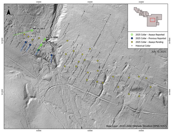
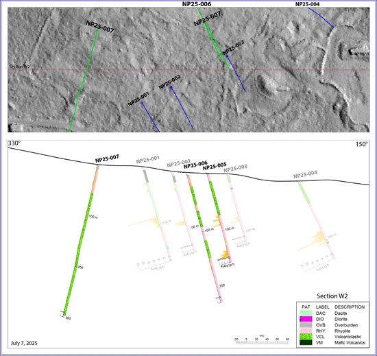
Figure 1 is a map of the Coronation area of the Lara Project, including all drillholes completed as part of the Phase 1 exploration program to date, also showing all historical collars. Figure 2 identifies the drillholes reported in this release. Figure 3 presents a geologic cross-section of these results, with intervals from Table 1 plotted for illustrative purposes. Table 1 summarizes all assay results disclosed herein, and Table 2 provides collar information for the reported drillholes.
Current Mineral Resources Estimate Targeted for Q4/2025
The Phase 1 exploration program is intended to verify up to 39,092 m of historical drilling across 245 holes in the Coronation area of the Lara Project, which previously supported a historical mineral resource estimate. The Company cautions that the historical estimate for the Coronation area is not a current mineral resource or reserve under National Instrument 43-101 Standards of Disclosure for Mineral Projects (“NI 43-101”), as a qualified person (“QP”) has not done sufficient work to classify it as such, and it should not be relied upon. The Company intends to verify historical drilling data through its Phase 1 exploration program to support a current mineral resource estimate targeted for Q4 2025, subject to successful exploration drilling and the timely receipt of final assay results. In anticipation of this, Mineit Consulting Inc. has been engaged to prepare an updated technical report for the Lara Project, under the supervision of Greg Mosher, M.Sc., P.Geo.
Advancing Lara’s Regional Exploration Potential Through Evaluation of Additional Targets
Coronation is just one of several high-priority targets within Nova Pacific’s 17-kilometre VMS belt on Vancouver Island. The belt lies within the prospective McLaughlin Ridge Formation, a correlative volcanic sequence that hosts the past-producing Myra Falls VMS Mine, and remains underexplored despite favourable geology and nearby infrastructure. The Lara Project spans 19 mineral claims covering 47 square kilometres, with an unverified historical dataset that includes 323 drillholes totalling 58,262 m of drilling.
Although the Coronation area has attracted most of the historical work, Nova Pacific has begun evaluating six additional mineralized zones across the property, many of which contain historical drill holes. These zones are largely untested and form a key part of the Company’s strategy to define resources at the Lara Project beyond the Coronation area. Field programs, including mapping, systematic sampling, and historical data compilation, will be used to refine targets and support future drilling. The potential for lens stacking and stratigraphic clustering, characteristic of VMS camps, further strengthens the broader exploration thesis.
Sampling, Quality Assurance and Quality Control
All drill core is logged by a geologist, photographed, and cut in half at Nova Pacific’s core facility near Nanaimo, British Columbia. One half of the core is bagged and sent to ALS Canada Ltd. (ALS) in North Vancouver for analysis, while the other half is retained on site as a witness sample. ALS North Vancouver is ISO/IEC 17025 accredited, and all samples are analyzed using industry-standard fire assay, multi-element ICP methods following four-acid digestion, and, where applicable, overlimit assays for high-grade. In addition to the laboratory’s QA/QC practices, certified reference materials, blanks, and duplicates are inserted into the sample stream at regular intervals to monitor analytical accuracy. Only results that meet Nova Pacific’s QA/QC protocols are reported.
Qualified Person
The pertinent scientific and technical information contained in this news release has been reviewed and approved by David Nelles, P.Geo., Jeremy Link, M.Eng., P.Eng., and Greg Mosher, M.Sc., P.Geo. of Mineit Consulting Inc., each of whom is a consultant of the Company and a “qualified person” as defined by NI 43-101. Exploration and technical programs at the Lara Project are managed by Mr. Link and Darcy Vis, P.Geo., of Tripoint Geological Services Ltd.
Rights of Indigenous Communities Statement
Nova Pacific Metals recognizes the inherent Rights of all Indigenous Peoples of Canada and is committed to early, meaningful, and respectful engagement with First Nations communities. The Company acknowledges that its Lara Project is located on the Traditional, Ancestral, and Unceded Territories of the Hul’qumi’num Treaty Group, a politically unified group representing six Hul’qumi’num-speaking First Nations: Cowichan, Stz’uminus, Penelakut, Lyackson, Halalt, and Lake Cowichan.
Nova Pacific pursues early consultation and meaningful engagement with First Nations communities to ensure that the Company’s mineral exploration and development activities are aligned with local priorities, values, and cultural protocols, while optimizing opportunities for collaboration. In particular, the Company seeks to establish mutually beneficial partnerships with Indigenous groups within whose traditional territories the Company’s projects are located. All work programs are carefully planned to achieve high levels of environmental and social performance, while advancing reconciliation and economic opportunities within Indigenous communities.
About Nova Pacific
Nova Pacific Metals Corp. is a Canadian exploration and development company advancing the Lara Volcanogenic Massive Sulfide (VMS) Project on Vancouver Island, British Columbia. The Company has an option to acquire a 100% interest in the Lara Project, which hosts a significant historical mineral resource enriched with critical and precious metals and is strategically located near key infrastructure. Nova Pacific’s strategy includes verification and exploration drilling to support a current mineral resource, with additional technical and exploration studies under consideration. The Company is committed to creating value for its shareholders while supporting environmental responsibility and strong community relationships.
For additional information please visit: www.novapacificmetals.com.
On behalf of the Board of Directors
Sam Eskandari, CEO
For investor inquiries, or for further information, please contact:
Nova Pacific Metals Corp.
+1-416-918-6785
The Canadian Securities Exchange has not in any way passed upon the merits of the matters referenced herein and has neither approved nor disapproved the contents of this news release.
Forward-Looking Information
Certain statements contained in this news release may constitute forward‐looking information including, without limitation, statements regarding the Company’s exploration plans. Forward‐looking information is often, but not always, identified by the use of words such as “anticipate”, “plan”, “estimate”, “expect”, “may”, “will”, “intend”, “should”, and similar expressions. Forward‐looking information involves known and unknown risks, uncertainties and other factors that may cause actual results or events to differ materially from those anticipated in such forward‐looking information. The Company believes that the expectations reflected in the forward‐looking information are reasonable, but no assurance can be given that these expectations will prove to be correct and such forward‐looking information should not be unduly relied upon. The Company’s actual results could differ materially from those anticipated in this forward‐looking information.
Forward looking information in this news release includes, but is not limited to, the Company’s objectives, goals or future plans; statements regarding exploration results, potential mineralization, the potential to expand mineralization through step-out drilling targeting down-plunge extensions, or verification of historical drilling results; the success of the new structural model in guiding exploration and identifying new mineralization; the Company’s plans to execute and complete its Phase 1 exploration program including the completion of a current mineral resource estimate; exploration and mine development plans; statements regarding regional exploration potential and the ability to develop exploration targets, drill targets, and define resources; the establishment of mutually beneficial partnerships with Indigenous communities; and the timing of the commencement of operations and estimates of market conditions. Factors that could cause actual results to differ materially from such forward-looking information include, but are not limited to, failure to intersect potentially economic intervals of mineralization; uncertainties related to the geological continuity, potential mineralization, and extent of down-plunge mineralization, which may not yield economically viable results; uncertainties in the accuracy of the new structural model, which may not accurately predict mineralization locations or continuity; additional mineralized zones may not contain economically viable mineralization due to geological complexity or insufficient drilling data; risks that historical drilling data may be incomplete, inaccurate, or insufficient to support a current mineral resource estimate; delays in assay processing or data validation issues; failure to identify mineral resources; the preliminary nature of metallurgical test results; delays in obtaining or failures to obtain required governmental, environmental or other project approvals; political risks; inability to fulfill the duty to accommodate First Nations and other Indigenous peoples; uncertainties relating to the availability and costs of financing needed in the future; changes in equity markets; inflation; changes in exchange rates; fluctuations in commodity prices; delays in the development of projects; capital and operating costs varying significantly from estimates; and the other risks involved in the mineral exploration and development industry. Although the Company believes that the assumptions and factors used in preparing the forward-looking information in this news release are reasonable, undue reliance should not be placed on such information, which only applies as of the date of this news release, and no assurance can be given that such events will occur in the disclosed time frames or at all. The Company disclaims any intention or obligation to update or revise any forward‐looking information whether as a result of new information, future events or otherwise, except as required by applicable securities legislation.
Table 1: Lara VMS Project – Coronation area assay results in this release
| Drillhole | From | To | Interval | True Width (m) | AuEq | ZnEq | Au | Zn | Ag | Cu | Pb | Section |
| ID | (m) | (m) | (m) | (g/t) | (%) | (g/t) | (%) | (g/t) | (%) | (%) | Line | |
| NP25-005 | 73.67 | 82 | 8.33 | 7.22 | 1.0 | 2.3 | 0.8 | 0.05 | 13.4 | 0.01 | 0.01 | W2 |
| and | 135 | 146 | 11 | 9.53 | 1.8 | 4.3 | 1.1 | 0.55 | 17.8 | 0.26 | 0.09 | |
| NP25-006 | No significant intervals |
W2 | ||||||||||
| NP25-007 | No significant intervals |
W2 | ||||||||||
- Intervals are reported over a minimum downhole length of 2 m at a minimum length-weighted grade of 0.5 g/t AuEq, allowing for up to 2 m of consecutive internal dilution below cut-off.
- High-grade intercepts reported as any continuous interval with grades greater than 10 g/t AuEq. No assays were capped.
- Interval refers to down-hole lengths. True width is estimated to be 87% of interval based upon drilling historical data.
- AuEq (gold equivalent) and ZnEq (zinc equivalent) are provided for illustrative purposes. AuEq and ZnEq combine gold, zinc, silver, copper, and lead, with secondary metals calculated net of assumed metallurgical recoveries using deposit-average recovery assumptions provided by Mineit Consulting Inc. of 86% for gold, 73% for zinc, 84% for silver, 95% for copper, and 96% for lead. Metal prices reflect three-year trailing averages of $2,200/oz gold, $1.25/lb Zn, $25.50/oz silver, $3.95/lb copper, and $0.95/lb lead. The resultant AuEq formula is AuEq [g/t] = Au [g/t] + 1.168 × Cu [%] + 0.285 × Pb [%] + 0.285 × Zn [%] + 0.0097 × Ag [g/t]. The resulting ZnEq formula is ZnEq [%] = Zn [%] + 1.223 × Cu [%] + 0.391 × Pb [%] + 0.034 × Au [g/t] + 0.0077 × Ag [g/t].
Table 2: Lara VMS Project – Drillhole collars reported in this release (EPSG:3157)
| Drillhole | Easting | Northing | Length | Azimuth | Dip | Line |
| ID | (m) | (m) | (m) | (°) | (°) | |
| NP2025-005 | 433,524 | 5,414,952 | 156 | 210 | -60 | W2 |
| NP2025-006 | 433,545 | 5,415,009 | 228 | 210 | -60 | W2 |
| NP2025-007 | 433,438 | 5,415,095 | 297 | 254 | -49 | W2 |
Figure 1: Lara VMS Project – Coronation area Phase 1 drillhole locations
To view an enhanced version of this graphic, please visit:
https://images.newsfilecorp.com/files/10425/258831_3634dec3a4a4c9bc_001full.jpg
Figure 2: Lara VMS Project – Coronation area Phase 1 results reported in this release
To view an enhanced version of this graphic, please visit:
https://images.newsfilecorp.com/files/10425/258831_3634dec3a4a4c9bc_002full.jpg
Figure 3: Lara VMS Project – Geological section looking N060°
To view an enhanced version of this graphic, please visit:
https://images.newsfilecorp.com/files/10425/258831_3634dec3a4a4c9bc_003full.jpg

To view the source version of this press release, please visit https://www.newsfilecorp.com/release/258831

