First Majestic Announces Results of the 2025 Drilling Program at Jerritt Canyon Gold Mine
Exploration drilling results underscore the potential for further Mineral Resource expansion
Vancouver, British Columbia–(Newsfile Corp. – March 10, 2026) – First Majestic Silver Corp. (NYSE: AG) (TSX: AG) (FSE: FMV) (the “Company” or “First Majestic”) is pleased to announce the results of a successful 2025 exploration program at its Jerritt Canyon Gold Mine (“Jerritt Canyon”) located in Nevada, USA, including the Mahala, Javelin, and Saval targets within the Smith-SSX-Saval mining area. The Company believes these results underscore the potential for expanding gold Mineral Resources at Jerritt Canyon to include both open-pit and underground resources.
“The success of our 2025 drilling program at Jerritt Canyon reaffirms our confidence in the potential of this district,” said Keith Neumeyer, CEO of First Majestic. “With the improved metal price environment, our team has expanded its focus to test both known underground targets as well as open-pit opportunities, which have yielded encouraging results. The results of the 2025 exploration program further highlight the potential for Mineral Resource growth. Jerritt Canyon hosts a significant district-scale land package of more than 30,000 hectares, and we have always believed that unlocking the district’s full potential requires continued investment in exploration. The results from our 2025 drill program represent an important step toward that vision.”
2025 EXPLORATION HIGHLIGHTS
In 2025, First Majestic completed an extensive drilling campaign at Jerritt Canyon totalling approximately 18,300 metres (“m”) across 57 drill holes. The program was strategically designed to explore for new gold mineralized zones beneath non-favourable “cover” rocks, as well as to assess the continuity of known mineralization beyond the boundaries of existing Inferred Mineral Resources along established geological trends. Targets included areas that have deeper underground and/or near-surface open pit potential.
Given the property’s history of both open pit and underground mining, the 2025 drilling results highlight the potential for Mineral Resources amenable to both mining methods: significant underground intercepts are defined by a minimum length of 4.6 m and a gold (“Au”) cut-off grade of 1.13 g/t, while significant open pit intercepts require at least 9.1 m and 0.43 g/t Au cut-off grade (see footnotes in the intercept tables for further criteria).
KEY DRILLING HIGHLIGHTS
Table 1 presents a selection of drill hole intercepts with significant assay results from the 2025 drill program at Jerritt Canyon, and Figure 1 highlights the areas with significant gold drilling intercepts across the district.
Table 1: Selection of Significant Gold Drill Hole Intercept Highlights from the 2025 Jerritt Canyon Drill Program
| Drillhole | Target | Significant Intercept | |||
| From (m) |
To (m) |
Drilled Length (m) |
Metal Grades | ||
| MA-25-017 | Mahala/Javelin | 294.1 | 318.5 | 24.4 | 3.43 g/t Au |
| MA-25-008 | Mahala/Javelin | 137.2 | 144.8 | 7.6 | 9.43 g/t Au |
| MA-25-009 | Mahala/Javelin | 141.7 | 160 | 18.3 | 2.23 g/t Au |
| MA-25-008 | Mahala/Javelin | 161.5 | 179.8 | 18.3 | 2.19 g/t Au |
| SC-25-003 | Saval | 195.1 | 246.9 | 51.8 | 1.48 g/t Au |
Note: True Width is currently unknown due to the uncertain nature of mineralization orientation; however, given the mainly sub-horizontal, stratigraphic controls, and near vertical drilling from surface, True Width is not expected to differ materially from Drilled Length.
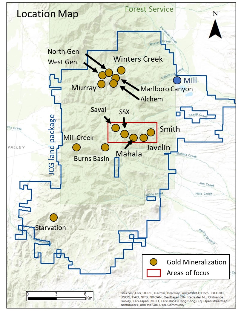
Figure 1: Jerritt Canyon District Map Highlighting Areas with Significant Gold Drilling Intercepts
To view an enhanced version of this graphic, please visit:
https://images.newsfilecorp.com/files/1475/288026_b02e2270c4474900_002full.jpg
Mahala to Javelin – Expansion Corridor
The Mahala and Javelin targets are situated between the Smith and SSX underground mines. See Figure 2 below identifying the Area of Interest (“AOI”). Mahala is one of the district’s larger known Inferred Mineral Resource areas, and there is modeled geological continuity between Mahala and Javelin. In 2023, drilling at Javelin produced several significant intercepts including 8.76 g/t Au over 15.2 m (hole SMI-230011) and 7.44 g/t Au over 15.7 m (hole SMI-230013), as reported in 2024 (see the Company’s news release dated February 7, 2024). A detailed review completed in early 2025 identified expansion potential for both targets within an area of approximately 600 m by 600 m. The review also highlighted possible increases in the interpreted thickness of the Javelin gold mineralization.
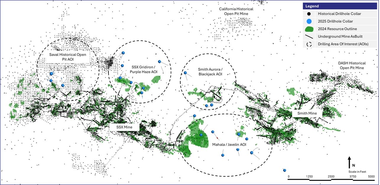
Figure 2: Saval / SSX / Mahala / Javelin / Smith Location Map
To view an enhanced version of this graphic, please visit:
https://images.newsfilecorp.com/files/1475/288026_b02e2270c4474900_003full.jpg
Javelin
A review of the Javelin target revealed that previous drilling, which was carried out from underground, intersected the mineralization at angles that were nearly parallel to the mineralization controls. Consequently, the true thickness of mineralization was not accurately determined, suggesting the potential for volume upside in resource estimation. The 2025 drill program tested the target from surface, allowing for drill-holes oriented at near sub-perpendicular angles to the interpreted gold mineral trend.
Drill-hole MA-25-008, the first hole completed in the program, returned geological and assay results indicating that the gold zone of interest is thicker than previously modeled. Based on these results, three additional step-out holes were completed to test lateral continuity: MA-25-009 targeted northwesterly continuity, MA-25-010 tested southerly continuity, and MA-25-011 tested southeasterly continuity. All holes, except for MA-25-010, intersected significant intervals of gold mineralization, supporting the interpreted continuity of the system. See a plan view in Figure 3 and cross section in Figure 4 below, showing the results of the program.
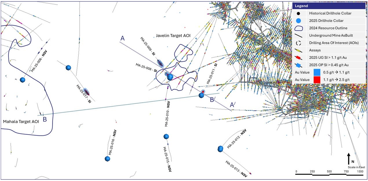
Figure 3: Mahala / Javelin Corridor Planview with A to A’ and B to B’ Cross Section Locations
To view an enhanced version of this graphic, please visit:
https://images.newsfilecorp.com/files/1475/288026_b02e2270c4474900_004full.jpg
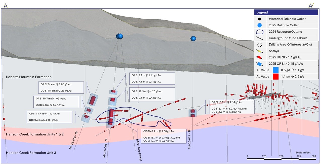
Figure 4: Javelin A to A’ Cross Section with 2025 Drilling (See Figure 3 with Cross Section Definition). Section projection is +/- 100 m
To view an enhanced version of this graphic, please visit:
https://images.newsfilecorp.com/files/1475/288026_b02e2270c4474900_005full.jpg
Mahala
The review of the Mahala target indicates that the previously defined AOI has the potential to expand along projected gold mineralized trends. The currently defined Mahala resources are modeled predominantly below the interpreted water table; however, geological modelling identified potential for mineralization to extend eastward where the stratigraphy rises above the known water table.
Two drill-holes were completed to test this expansion potential to the east toward the Javelin target and to the north. Drill-hole MA-25-017, collared approximately 200 m east of the known Mahala resource boundary, intersected broad disseminated mineralization of 47.2 m grading 2.75 g/t Au, including two separate high-grade intercepts of 24.4 m at 3.44 g/t Au and 10.7 m at 3.17 g/t Au (see Figure 5 below showing cross-section details). These results indicate that Mahala gold mineralization remains open to the east in the direction of the Javelin target.
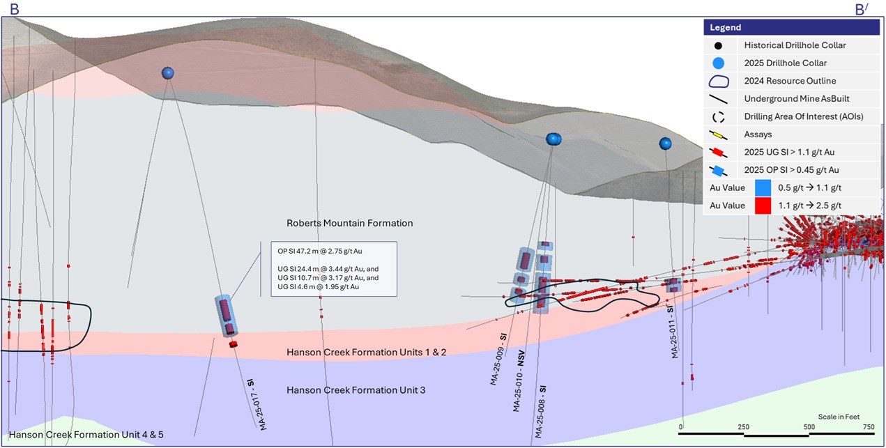
Figure 5: Mahala / Javelin B to B’ Cross Section (See Figure 3 with Cross Section Definition). Section Projection +/- 100 m
To view an enhanced version of this graphic, please visit:
https://images.newsfilecorp.com/files/1475/288026_b02e2270c4474900_006full.jpg
Saval Historical Open Pit Target
An additional near-mine AOI focused on shallow mineralization in the vicinity of the historical Saval open pits. The deposit is characterized by structurally controlled, stratigraphically bound Carlin-style mineralization. See Figure 6 below showing the AOI with the location of the 2025 drill holes.
This geological setting is associated with broad, low to high-grade, sub-horizontal mineralized zones, which are amenable to near-surface open pit mining methods. A targeted review around the previously mined Saval open pits identified gaps in historical drilling coverage along interpreted mineralized trends.
The 2025 drill program tested the potential for near-surface mineralization within these open trends and evaluated opportunities for expansion adjacent to the historical workings. Several drill-holes completed at the West Saval Historical Open Pit AOI intersected shallow, broad intervals of lower-grade gold mineralization.
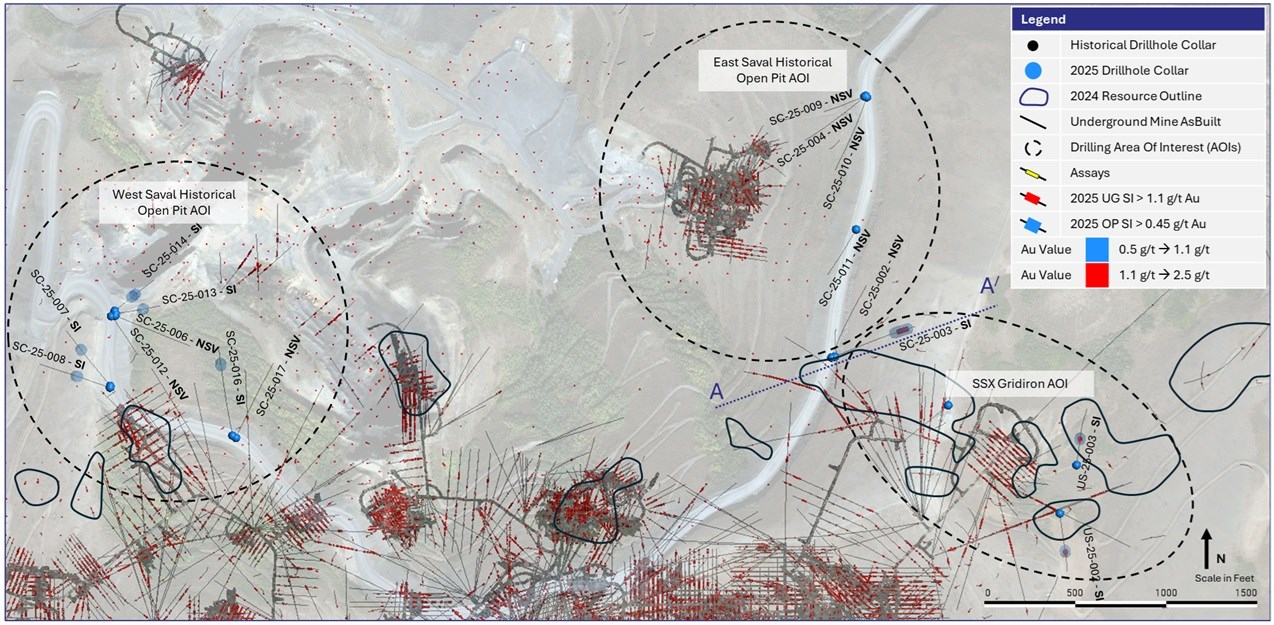
Figure 6: Saval Historical Pit to SSX Gridiron Corridor Planview, with Cross-section line A-A’
To view an enhanced version of this graphic, please visit:
https://images.newsfilecorp.com/files/1475/288026_b02e2270c4474900_007full.jpg
At the East Saval Historical Open Pit AOI, drill-hole SC-25-003 intersected a significant interval of 51.8 m grading 1.48 g/t Au, including a higher-grade intercept of 12.2 m at 3.23 g/t Au. The geological continuity of this intercept remains uncertain at this stage. Mineralization may represent a linkage to the underground SSX Gridiron target, or alternatively, an eastward extension of the Saval mineralized trend. See Figure 7 below for a cross section of the results. Further drilling will be required to better constrain the geometry and continuity of this zone.
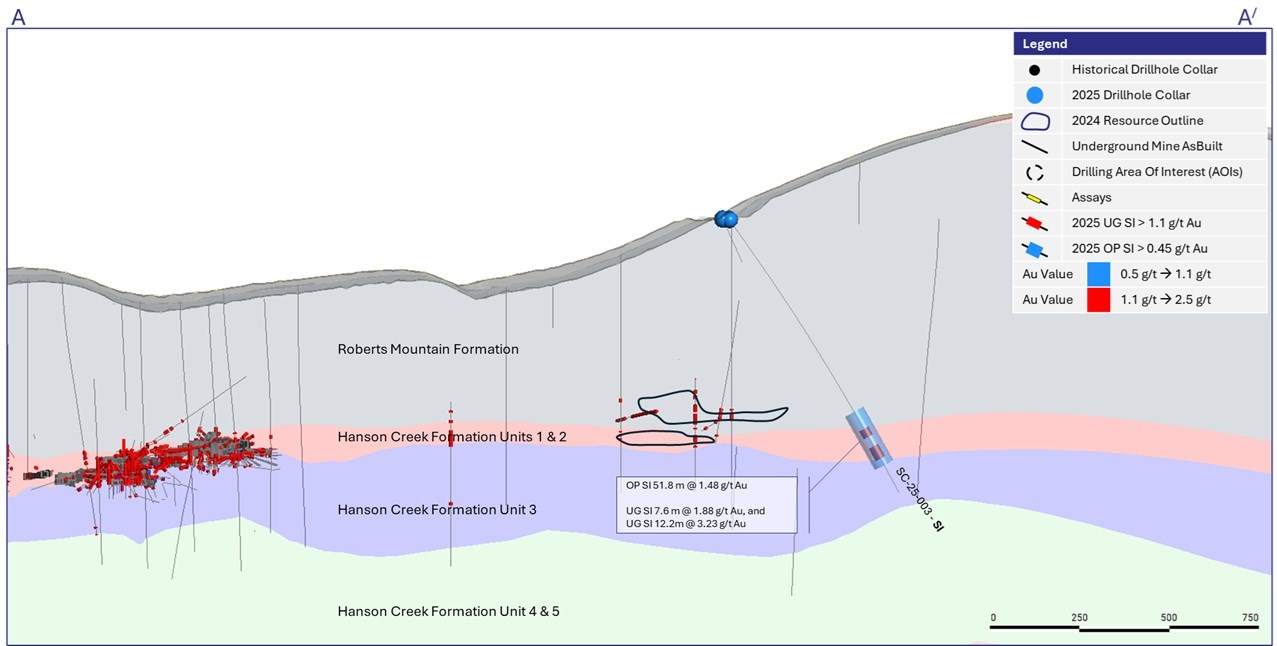
Figure 7 – East Saval Cross-Section (See Figure 6 for Cross-Section Definition). Section thickness +/- 50 m
To view an enhanced version of this graphic, please visit:
https://images.newsfilecorp.com/files/1475/288026_b02e2270c4474900_008full.jpg
Table 2: Summary of Significant Underground Potential Gold Drill Hole Intercepts at Jerritt Canyon
| Drillhole | Target | Target Type | Significant Intercept | |||
| From (m) |
To (m) |
Interval Length (m) |
Au (g/t) |
|||
| GH-25-001 | Boilermaker | Drill Testing | 128.0 | 132.6 | 4.6 | 1.37 |
| GH-25-003 | Boilermaker | Drill Testing | 144.8 | 149.4 | 4.6 | 1.66 |
| GH-25-005 | Murray | Drill Testing | 114.3 | 118.9 | 4.6 | 1.75 |
| GH-25-005 (2) | Murray | Drill Testing | 131.1 | 141.7 | 10.7 | 1.83 |
| GR-25-003 | Murray | Drill Testing | 332.2 | 336.8 | 4.6 | 4.56 |
| GR-25-003 (inc) | Murray | Drill Testing | 333.8 | 335.3 | 1.5 | 12.30 |
| MA-25-002 | Blackjack | Drill Testing | 265.2 | 269.8 | 4.6 | 1.66 |
| MA-25-002 (2) | Blackjack | Drill Testing | 281.9 | 292.6 | 10.7 | 1.62 |
| MA-25-008 | Javelin | Drill Testing | 120.4 | 125.0 | 4.6 | 2.11 |
| MA-25-008 (2) | Javelin | Drill Testing | 137.2 | 144.8 | 7.6 | 9.43 |
| MA-25-008 (inc) | Javelin | Drill Testing | 138.7 | 143.3 | 4.6 | 12.60 |
| MA-25-008 (3) | Javelin | Drill Testing | 161.5 | 179.8 | 18.3 | 2.19 |
| MA-25-008 (4) | Javelin | Drill Testing | 182.9 | 196.6 | 13.7 | 2.07 |
| MA-25-009 | Javelin | Drill Testing | 147.8 | 166.1 | 18.3 | 2.23 |
| MA-25-009 (2) | Javelin | Drill Testing | 178.3 | 182.9 | 4.6 | 1.47 |
| MA-25-009 (3) | Javelin | Drill Testing | 193.5 | 198.1 | 4.6 | 2.90 |
| MA-25-011 | Javelin | Drill Testing | 158.5 | 164.6 | 6.1 | 3.93 |
| MA-25-011 (2) | Javelin | Drill Testing | 169.2 | 173.7 | 4.6 | 1.78 |
| MA-25-017 | SSX Mahala | Drill Testing | 294.1 | 318.5 | 24.4 | 3.44 |
| MA-25-017 (2) | SSX Mahala | Drill Testing | 324.6 | 335.3 | 10.7 | 3.17 |
| MA-25-017 (3) | SSX Mahala | Drill Testing | 347.5 | 352.0 | 4.6 | 1.95 |
| US-25-002 | USB | Drill Testing | 222.5 | 228.6 | 6.1 | 1.66 |
| US-25-003 | USB | Drill Testing | 167.6 | 175.3 | 7.6 | 1.88 |
| WW-25-001 | Murray | Drill Testing | 281.9 | 289.6 | 7.6 | 1.34 |
| WC-25-004 | Winter’s Creek | Drill Testing | 117.3 | 125.0 | 7.7 | 6.25 |
| WC-25-004 (inc) | Winter’s Creek | Drill Testing | 120.4 | 123.4 | 3.0 | 11.85 |
| SC-25-003 | Saval Expansion | Drill Testing | 211.8 | 219.5 | 7.6 | 1.88 |
| SC-25-003 (2) | Saval Expansion | Drill Testing | 228.6 | 240.8 | 12.2 | 3.23 |
Notes:
- All holes are Reverse Circulation (“RC”).
- From and To length indicated in metres, true width of the intercept is not known at this time.
- See Appendix to this news release for details regarding drill hole locations, sample type, azimuth, dip and total depth.
- Gold drill hole significant intercepts were composited using the length weighted averages of uncapped sample assays, a 1.13 g/t Au minimum cut-off grade (“COG”); minimum composite length of 4.6 m (drilled width). A maximum of 4.6 m below the minimum COG was allowed as internal dilution. Where necessary to achieve minimum length, a single sample below the COG was allowed to be composited for short intervals.
- Where present, single samples or intercepts with assay results higher than 10 g/t Au are highlighted as “Include” in each intercept.
Table 3: Summary of Significant Open Pit Potential Gold Drill Hole Intercepts at Jerritt Canyon
| Drillhole | Target | Target Type | Significant Intercept | |||
| From (m) |
To (m) |
Interval Length (m) |
Au (g/t) |
|||
| GH-25-003 | Boilermaker | Drill Testing | 155.4 | 169.2 | 13.7 | 0.84 |
| GH-25-005 | Murray | Drill Testing | 131.1 | 141.7 | 10.7 | 1.83 |
| MA-25-002 | Blackjack | Drill Testing | 262.1 | 292.6 | 30.5 | 1.13 |
| MA-25-004 | Blackjack | Drill Testing | 271.3 | 285.0 | 13.7 | 0.49 |
| MA-25-005 | Hades | Drill Testing | 271.3 | 281.9 | 10.7 | 0.55 |
| MA-25-008 | Javelin | Drill Testing | 120.4 | 129.5 | 9.1 | 1.41 |
| MA-25-008 (2) | Javelin | Drill Testing | 135.6 | 153.9 | 18.3 | 4.26 |
| MA-25-008 (2 inc) | Javelin | Drill Testing | 137.2 | 144.8 | 7.6 | 9.43 |
| MA-25-008 (3) | Javelin | Drill Testing | 157.0 | 204.2 | 47.2 | 1.66 |
| MA-25-009 | Javelin | Drill Testing | 143.3 | 167.6 | 24.4 | 1.85 |
| MA-25-009 (2) | Javelin | Drill Testing | 175.3 | 185.9 | 10.7 | 1.09 |
| MA-25-009 (3) | Javelin | Drill Testing | 193.5 | 207.3 | 13.7 | 1.43 |
| MA-25-011 | Javelin | Drill Testing | 158.5 | 173.7 | 15.2 | 2.14 |
| MA-25-017 | SSX Mahala | Drill Testing | 289.6 | 336.8 | 47.2 | 2.75 |
| MA-25-017 (inc) | SSX Mahala | Drill Testing | 303.3 | 307.9 | 4.6 | 5.32 |
| US-25-002 | USB | Drill Testing | 219.5 | 239.3 | 19.8 | 0.94 |
| US-25-003 | USB | Drill Testing | 167.6 | 184.4 | 16.8 | 1.14 |
| WW-25-001 | Murray | Drill Testing | 281.9 | 294.1 | 12.2 | 0.99 |
| WC-25-004 | Winter’s Creek | Drill Testing | 117.4 | 126.5 | 9.1 | 5.25 |
| WC-25-004 (inc) | Winter’s Creek | Drill Testing | 118.9 | 123.4 | 4.6 | 8.76 |
| SC-25-003 | Saval Expansion | Drill Testing | 195.1 | 246.9 | 51.8 | 1.48 |
| SC-25-007 | Saval Expansion | Drill Testing | 132.6 | 141.7 | 9.1 | 0.80 |
| SC-25-008 | Saval Expansion | Drill Testing | 106.7 | 118.9 | 12.2 | 0.81 |
| SC-25-013 | Saval Expansion | Drill Testing | 144.8 | 155.4 | 10.7 | 0.63 |
| SC-25-014 | Saval Expansion | Drill Testing | 103.6 | 114.3 | 10.7 | 0.46 |
| SC-25-014 (2) | Saval Expansion | Drill Testing | 120.4 | 129.5 | 9.1 | 0.49 |
| SC-25-016 | Saval Expansion | Drill Testing | 214.9 | 228.6 | 13.7 | 0.57 |
Notes:
- All drill holes were Reverse Circulation.
- From and To length indicated in metres, true width of the intercept is not known at this time.
- See Appendix to this news release for details regarding drill hole locations, sample type, azimuth, dip and total depth.
- Gold drill hole significant intercepts were composited using the length weighted averages of uncapped sample assays, a 0.43 g/t Au minimum cut-off grade (“COG”); minimum composite length of 9.1 m (drilled width). A maximum of 4.6 m below the minimum COG was allowed as internal dilution. Where necessary to achieve minimum length, a single sample below the COG was allowed to be composited for short intervals.
- Where present, single samples or intercepts with intervals of 4.6 m or greater with more than 5.0 g/t Au are highlighted as “Include” in each intercept.
- Intervals starting at depths under 300 m are considered suitable for potential Open Pit significant intercepts.
First Majestic’s 2025 drilling programs at Jerritt Canyon followed established Quality Assurance, Quality Control (“QA/QC”) insertion protocols with standards, blanks and duplicates introduced into the sample-stream. All RC drill-hole samples were placed in bags labeled with the hole ID, sample ID, and sample interval, and submitted to Bureau Veritas Minerals Laboratories (BV) (ISO/IEC 17025:2017) in Sparks, Nevada. At BV, samples were dried, crushed to 70% passing a 2 mm mesh and pulverized to 85% passing a 75 μm mesh. Gold was analyzed by lead collection Fire Assay fusion AAS finish (FA430). Results above 10 g/t Au were analyzed by 30 g lead collection Fire Assay fusion gravimetric finish (FA530).
For further information concerning QA/QC and data verification matters, key assumptions, parameters, and methods used by the Company to estimate Mineral Reserves and Mineral Resources, and for a detailed description of known legal, political, environmental, and other risks that could materially affect the Company’s business and the potential development of Mineral Reserves and Mineral Resources, see the Company’s most recently filed Annual Information Form available under the Company’s SEDAR+ profile at www.sedarplus.ca and the Company’s Annual Report on Form 40-F for the year ended December 31, 2024 filed with the United States Securities and Exchange Commission on EDGAR at www.sec.gov/edgar.
QUALIFIED PERSONS
Gonzalo Mercado, P. Geo., the Company’s Vice-President, Exploration & Technical Services and a “Qualified Person” as defined under National Instrument 43-101 Standards of Disclosure for Mineral Projects (“NI 43-101”), has reviewed and approved the scientific and technical information contained in this news release. Mr. Mercado has verified the exploration data contained in this news release, including the sampling, analytical and test data underlying such information.
ABOUT FIRST MAJESTIC
First Majestic is a publicly traded mining company focused on silver and gold production in Mexico and the United States. The Company presently owns and operates four producing underground mines in Mexico: the Santa Elena Silver/Gold Mine, the San Dimas Silver/Gold Mine, the Los Gatos Silver Mine (the Company holds a 70% interest in the Los Gatos Joint Venture that owns and operates the mine), and the La Encantada Silver Mine, as well as a portfolio of development and exploration assets, including the Jerritt Canyon Gold Mine located in northeastern Nevada, U.S.A.
First Majestic is proud to own and operate its own minting facility, First Mint, LLC, and to offer a portion of its silver production for sale to the public. Bars, ingots, coins, and medallions are available for purchase online at www.firstmint.com, at some of the lowest premiums available.
For further information, contact [email protected] visit our website at www.firstmajestic.com or call our toll-free number 1.866.529.2807.
FIRST MAJESTIC SILVER CORP.
“signed”
Keith Neumeyer, CEO
Cautionary Note Regarding Forward-Looking Statements
This news release contains “forward‐looking information” and “forward-looking statements” under applicable Canadian and U.S. securities laws (collectively, “forward‐looking statements”). These statements relate to future events or the Company’s future performance, business prospects or opportunities that are based on forecasts of future results, estimates of amounts not yet determinable and assumptions of management made in light of management’s experience and perception of historical trends. Forward-looking statements in this news release include but are not limited to statements with respect to: the potential to expand Mineral Resources at Jerritt Canyon; and the potential to develop open-pit Mineral Resources in addition to underground Mineral Resources. Assumptions may prove to be incorrect and actual results and future events may differ materially from those anticipated. As such, investors are cautioned not to place undue reliance upon forward-looking statements as there can be no assurance that the plans, assumptions, or expectations upon which they are placed will occur. Any statements that express or involve discussions with respect to predictions, expectations, beliefs, plans, projections, objectives or future events or performance (often, but not always, using words or phrases such as “seek”, “anticipate”, “plan”, “continue”, “estimate”, “expect”, “may”, “will”, “project”, “predict”, “forecast”, “potential”, “target”, “intend”, “could”, “might”, “should”, “believe” and similar expressions) are not statements of historical fact and may be “forward‐looking statements”. Statements concerning Mineral Resource estimates may also be deemed to constitute forward-looking statements to the extent that they involve estimates of the mineralization that will be encountered as and if the property is developed, and in the case of Measured and Indicated Mineral Resources, such statements reflect the conclusion based on certain assumptions that the mineral deposit can be economically exploited.
Actual results may vary from forward-looking statements. Forward-looking statements are subject to known and unknown risks, uncertainties and other factors that may cause actual results to materially differ from those expressed or implied by such forward-looking statements, including but not limited to: material adverse changes; general economic conditions including inflation risks; labour relations; relations with local communities; changes in national or local governments; exchange rate fluctuations; environmental risks; requirements for additional capital; outcomes of pending litigation; unexpected changes in laws, rules or regulations, or their enforcement by applicable authorities; the failure of parties to contracts with the company to perform as agreed; social or labour unrest; changes in commodity prices; and the failure of exploration programs or studies to deliver anticipated results or results that would justify and support continued exploration, studies, development or operations as well as those factors discussed in the section entitled “Description of Business – Risk Factors” in the Company’s most recent Annual Information Form for the year ended December 31, 2024 filed with the Canadian securities regulatory authorities under the Company’s SEDAR+ profile at www.sedarplus.ca and in the Company’s Annual Report on Form 40-F for the year ended December 31, 2024 filed with the United States Securities and Exchange Commission on EDGAR at www.sec.gov/edgar. Although the Company has attempted to identify important factors that could cause actual results to differ materially from those contained in forward-looking statements, there may be other factors that cause results not to be as anticipated, estimated, or intended.
The Company believes that the expectations reflected in these forward‐looking statements are reasonable, but no assurance can be given that these expectations will prove to be correct and such forward‐looking statements included herein should not be unduly relied upon. These statements speak only as of the date hereof. The Company does not intend, and does not assume any obligation, to update these forward-looking statements, except as required by applicable laws.
Cautionary Note to United States Investors
The Company is a “foreign private issuer” as defined in Rule 3b-4 under the United States Securities Exchange Act of 1934, as amended, and is eligible to rely upon the Canada-U.S. Multi-Jurisdictional Disclosure System, and is therefore permitted to prepare the technical information contained herein in accordance with the requirements of the securities laws in effect in Canada, which differ from the requirements of the securities laws currently in effect in the United States. Accordingly, information concerning mineral deposits set forth herein may not be comparable with information made public by companies that report in accordance with U.S. standards.
Technical disclosure contained in this news release has not been prepared in accordance with the requirements of United States securities laws and uses terms that comply with reporting standards in Canada with certain estimates prepared in accordance with NI 43-101.
NI 43-101 is a rule developed by the Canadian Securities Administrators that establishes standards for all public disclosure an issuer makes of scientific and technical information concerning the issuer’s material mineral projects.
APPENDIX – DRILL HOLE DETAILS
Table A1: Drill Hole Collar Location, Sample Type, Azimuth, Dip and Total Depth from Jerritt Canyon
| Drillhole | Actual East | Actual North | Actual Elev | Azimuth | Dip | Depth (m) | Type |
| BI-25-001 | 386096.3 | 416794.3 | 6669.1 | 195 | -77 | 690.37 | RC |
| BI-25-002 | 387824.4 | 417198.9 | 6991.1 | 0 | -83 | 580.64 | RC |
| GH-25-001 | 383196.0 | 422295.6 | 6794.3 | 75 | -70 | 214.88 | RC |
| GH-25-002 | 383178.9 | 422287.0 | 6793.7 | 185 | -60 | 214.88 | RC |
| GH-25-003 | 383438.0 | 422590.0 | 6894.4 | 284 | -70 | 213.36 | RC |
| GH-25-004 | 383182.9 | 422299.5 | 6794.4 | 140 | -65 | 204.22 | RC |
| GR-25-001 | 383568.9 | 419066.6 | 6945.1 | 295 | -78 | 486.16 | RC |
| GR-25-002 | 382568.8 | 421224.3 | 7121.0 | 270 | -85 | 393.19 | RC |
| GR-25-003 | 382586.0 | 421218.1 | 7120.6 | 65 | -70 | 393.19 | RC |
| GH-25-005 | 383574.4 | 421994.9 | 6757.9 | 75 | -65 | 188.98 | RC |
| MA-25-002 | 396207.1 | 406981.6 | 7632.5 | 300 | -80 | 304.80 | RC |
| MA-25-003 | 396210.0 | 406980.4 | 7632.7 | 45 | -84 | 336.80 | RC |
| MA-25-004 | 396507.9 | 407028.8 | 7636.1 | 325 | -85 | 307.85 | RC |
| MA-25-005 | 395522.2 | 406401.0 | 7846.8 | 260 | -77 | 457.20 | RC |
| MA-25-006 | 395889.5 | 405302.6 | 7647.9 | 30 | -55 | 502.92 | RC |
| MA-25-007 | 396498.8 | 407016.7 | 7636.0 | 240 | -58 | 457.20 | RC |
| MA-25-008 | 398056.9 | 405355.5 | 7245.6 | 300 | -85 | 364.24 | RC |
| MA-25-009 | 398067.3 | 405349.3 | 7245.4 | 320 | -62 | 274.32 | RC |
| MA-25-010 | 398056.6 | 405332.1 | 7245.8 | 190 | -65 | 277.37 | RC |
| MA-25-011 | 398518.7 | 405073.7 | 7228.6 | 30 | -85 | 243.84 | RC |
| MA-25-012 | 398801.3 | 404293.5 | 7222.4 | 40 | -70 | 393.19 | RC |
| MA-25-013 | 398797.8 | 404275.4 | 7222.2 | 125 | -60 | 350.52 | RC |
| MA-25-015 | 398002.6 | 404467.0 | 7224.5 | 165 | -75 | 458.72 | RC |
| MA-25-016 | 397138.1 | 404139.1 | 7466.4 | 0 | -80 | 518.16 | RC |
| MA-25-017 | 396563.2 | 405482.0 | 7498.3 | 140 | -60 | 457.20 | RC |
| MA-25-018 | 400693.7 | 403271.9 | 7309.1 | 0 | -90 | 763.52 | RC |
| SC-25-001 | 391874.7 | 408316.2 | 8108.8 | 230 | -68 | 265.18 | RC |
| US-25-001 | 394990.7 | 408875.6 | 7906.4 | 120 | -65 | 344.42 | RC |
| US-25-002 | 392487.6 | 407722.5 | 8057.7 | 170 | -72 | 365.76 | RC |
| US-25-003 | 392580.3 | 407987.8 | 8005.1 | 5 | -75 | 381.00 | RC |
| US-25-004 | 393506.0 | 409508.1 | 7847.4 | 160 | -55 | 434.34 | RC |
| US-25-005 | 393506.8 | 409515.9 | 7847.0 | 110 | -55 | 335.28 | RC |
| US-25-006 | 394988.5 | 408864.1 | 7906.4 | 165 | -60 | 338.33 | RC |
| WW-25-001 | 378310.2 | 421349.2 | 6696.7 | 150 | -60 | 457.20 | RC |
| WC-25-001 | 394900.3 | 427948.5 | 7621.5 | 325 | -75 | 213.36 | RC |
| WC-25-002 | 394890.6 | 427922.7 | 7621.6 | 150 | -75 | 184.40 | RC |
| WC-25-003 | 394166.1 | 427789.9 | 7640.3 | 100 | -60 | 245.36 | RC |
| WC-25-004 | 394169.2 | 427806.2 | 7639.9 | 10 | -65 | 178.31 | RC |
| WC-25-005 | 393816.9 | 428700.6 | 7420.5 | 320 | -60 | 213.36 | RC |
| WC-25-006 | 393820.5 | 428674.1 | 7422.5 | 145 | -60 | 27.43 | RC |
| WC-25-006A | 393825.6 | 428667.6 | 7422.9 | 145 | -60 | 137.16 | RC |
| WC-25-007 | 394141.9 | 428649.6 | 7440.9 | 0 | -90 | 185.93 | RC |
| WC-25-008 | 394146.6 | 428649.9 | 7440.8 | 85 | -65 | 216.41 | RC |
| SC-25-002 | 391233.7 | 408578.7 | 7766.2 | 20 | -60 | 289.56 | RC |
| SC-25-003 | 391251.7 | 408583.4 | 7765.4 | 65 | -55 | 274.32 | RC |
| SC-25-004 | 391415.9 | 410013.0 | 7746.1 | 230 | -65 | 335.28 | RC |
| SC-25-006 | 387297.2 | 408808.5 | 7584.8 | 110 | -55 | 239.27 | RC |
| SC-25-007 | 387271.4 | 408423.1 | 7619.6 | 320 | -55 | 213.36 | RC |
| SC-25-008 | 387270.2 | 408413.6 | 7620.6 | 290 | -57 | 243.84 | RC |
| SC-25-009 | 391421.8 | 410017.1 | 7746.0 | 245 | -70 | 243.84 | RC |
| SC-25-010 | 391427.5 | 410008.3 | 7746.1 | 200 | -65 | 335.28 | RC |
| SC-25-011 | 391369.4 | 409282.1 | 7755.6 | 210 | -70 | 274.32 | RC |
| SC-25-012 | 387277.3 | 408805.6 | 7583.4 | 140 | -70 | 243.84 | RC |
| SC-25-013 | 387300.8 | 408819.7 | 7583.9 | 80 | -70 | 243.84 | RC |
| SC-25-014 | 387296.0 | 408835.0 | 7582.6 | 50 | -70 | 243.84 | RC |
| SC-25-016 | 387943.0 | 408150.0 | 7672.6 | 350 | 55 | 274.32 | RC |
| SC-25-017 | 387961.7 | 408137.9 | 7674.1 | 25 | -55 | 266.70 | RC |
Notes:
- All drill hole collar coordinates are determined using total station equipment after hole completion with UTM WGS84, Zone 13 (metres) as the reference system.
![]()
To view the source version of this press release, please visit https://www.newsfilecorp.com/release/288026