Luma Hydrogen Fast-Tracks Nova Scotia Hydrogen and Helium Exploration with Completed 2D Seismic Survey and Integrated Soil-Gas Program
26 line-km of seismic data across the Cobequid-Chedabucto Fault Zone now in processing; results to be integrated with soil-gas data to define drill targets
Halifax, Nova Scotia–(Newsfile Corp. – October 21, 2026) – Luma Hydrogen Corp. (“Luma” or the “Company”), a private company exploring for geologic hydrogen and helium in Atlantic Canada, is pleased to announce that it engaged Echo Seismic Ltd. (“Echo Seismic“) of Calgary, Alberta to acquire approximately 26 line-kilometres of 2D Vibroseis seismic data across its licences in the Parrsboro-Springhill area of Cumberland County, Nova Scotia. The 2D seismic program was completed between October 16 and 20, 2026.
HIGHLIGHTS
-
Approximately 26 line-km of high-resolution 2D Vibroseis data was acquired along existing forestry roads within Luma’s Nova Scotia licence package in Cumberland County (Figure 1).
-
Seismic lines were designed to image fault architecture, structural traps and potential seals along the Cobequid-Chedabucto Fault Zone.
-
Seismic interpretations will be integrated with Luma’s 2026 soil-gas hydrogen and helium survey to rank drill targets for a maiden drill program planned for 2027. The Company’s soil geochemistry survey, prospecting and mapping program, and soil-gas surveys are also underway.
-
Echo Seismic acted as prime contractor for the Vibroseis recording operations, with Resourceful Geoscience Solutions Inc. (“RGS“) managing field logistics and permitting.
SEISMIC PROGRAM DESIGN AND PROCESSING
Luma’s Nova Scotia exploration licences lie along the Cobequid-Chedabucto Fault Zone at the northern margin of the Cumberland Basin, an area that has seen growing geologic hydrogen and helium exploration activity in 2026, including recent seismic surveys and drilling programs on adjacent exploration licences owned by Québec Innovative Materials Corp. (CSE: QIMC).
The seismic survey lines were designed by Luma’s technical team, including Technical Lead Dr. Allegra Hosford Scheirer, using the most recent airborne geophysical surveys, geological mapping data, and historical exploration data available for the region. The survey lines were positioned to cross the main fault strands of the crustal-scale Cobequid-Chedabucto Fault Zone and adjoining basin margins. The objective of the seismic program is to map the faults that may act as migration pathways for deep-sourced hydrogen and helium, and to identify any structural closures and sealing units where gas could accumulate.
Echo Seismic acquired the seismic data with an INOVA Quantum nodal recording system of approximately 1,400 channels, using single 5 Hz geophone nodes at 25-metre receiver spacing. Two fleets of two Mertz M18 44,000-lb Vibroseis units provided the energy source at 50-metre source intervals, with a 6-120 Hz sweep and a 6-second record length. All seismic lines followed existing forestry roads, so no line construction was required and there was minimal surface disturbance. The Luma seismic program was completed in collaboration with QIMC’s own 2D seismic program in the area.
Echo Seismic Ltd. is a full-service land seismic acquisition contractor with more than 20 years of experience, operating INOVA Quantum nodal recording systems and Vibroseis fleets across Canada, including recent seismic programs on adjacent properties in Nova Scotia.
Earth Signal Processing Ltd. (“Earth Signal“) of Calgary, Alberta has been engaged to process the 2D seismic data collected by Echo Seismic. Operating since 1993, Earth Signal has processed more than 27,600 2D seismic lines in over 63 countries, including previous work in the Cumberland Basin. Earth Signal will apply its proprietary noise-attenuation and imaging workflows to resolve the faults, stratigraphic boundaries, and structural features central to geologic hydrogen and helium targeting, incorporating available well and geological control. The processed sections will then go to Luma’s technical team for interpretation and integration with the Company’s soil-gas and prospecting results for future drill planning.
ONGOING FIELD PROGRAM
Alongside the 2D seismic program, Luma’s field crew continue to advance soil sampling, prospecting, and soil-gas testing for hydrogen and helium across its Nova Scotia licences. This work is expected to continue for a further six weeks. These results will be combined with the seismic data to build an integrated target model ahead of drilling.
ATLANTIC CANADIAN EXPERTISE ON THE GROUND
Luma has chosen a Nova Scotia-based team to support its field programs. Halifax-based Resourceful Geoscience Solutions Inc. coordinated field logistics, landowner and road-use permitting, and regulatory requirements for the seismic survey, working alongside Luma’s management and technical team, and Echo Seismic. RGS already provides hands-on support to Luma’s soil-gas and prospecting program, so the seismic and surface-geochemistry work is being run by one integrated field team. RGS’s commitment to driving strategic exploration through geoscientific first principles match Luma’s approach of building a complete geological and geophysical picture before advancing to drilling.
MANAGEMENT COMMENTARY
“Seismic acquisition is a key step alongside our soil-gas work,” said Paul Ténière, CEO of Luma Hydrogen. “Soil gas tells us where hydrogen and helium may be reaching surface. Seismic tells us what is happening at depth: where the faults are, how they connect and where traps could sit. Echo Seismic delivered with a proven Vibroseis crew with Atlantic Canadian experience, and working from existing forestry roads kept our footprint low. Coordinating our program with QIMC’s produced meaningful cost savings and the start of a constructive working relationship as the district develops. With Earth Signal, which has already worked in the Cumberland Basin, processing the data, this combined dataset will be central to choosing where we drill in 2027.”
ABOUT LUMA’S NOVA SCOTIA GEOLOGIC HYDROGEN AND HELIUM PROJECT
The project comprises 30 exploration licences covering approximately 274 km² (27,440 ha) along one of the largest crustal-scale fault systems in Atlantic Canada. The Cobequid-Chedabucto Fault Zone transects the Carboniferous Cumberland Basin, juxtaposing deep basement structures capable of channelling hydrogen upward against thick evaporite and shale sequences that can act as regional seals. Luma’s licences sit within a rapidly developing hydrogen and helium corridor defined by third-party drilling, soil-gas work, and recently acquired 2D seismic data (Figure 2).
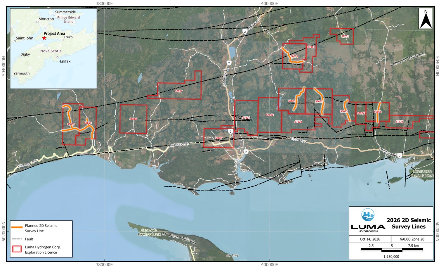
Figure 1: Luma 2D seismic program in Cumberland County, Nova Scotia
To view an enhanced version of this graphic, please visit:
https://images.newsfilecorp.com/files/12664/320171_988ed195a427a956_001full.jpg
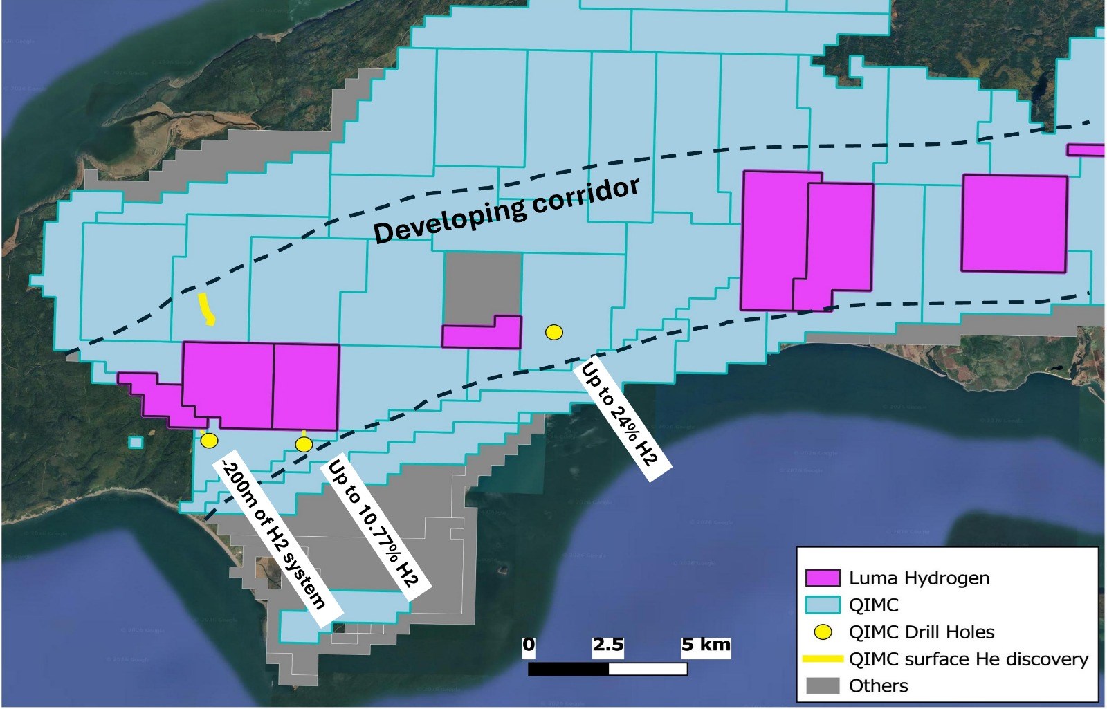
Figure 2: Developing structural corridor in Nova Scotia hosting geologic hydrogen
To view an enhanced version of this graphic, please visit:
https://images.newsfilecorp.com/files/12664/320171_988ed195a427a956_002full.jpg
CAUTIONARY NOTE REGARDING ADJACENT PROPERTIES
This news release contains information with respect to adjacent or nearby properties in which the Company has no interest or right to explore or mine, including properties held by Quebec Innovative Materials Corp. (CSE: QIMC). References to soil-gas readings, drill results, market capitalizations, transactions or other information concerning these or any other third-party issuers are derived from public disclosure by those issuers and have not been independently verified by the Company. Readers are cautioned that mineral or hydrogen occurrences, results or discoveries on adjacent or nearby properties are not necessarily indicative of, and provide no assurance as to, the presence of hydrogen, helium, mineralization or any exploration results on the Company’s properties. The Company has not conducted any drilling on its properties and has not established the presence of any hydrogen or helium accumulation on any of its licences.
QUALIFIED PERSON STATEMENT
The scientific and technical information contained in this news release has been reviewed and approved by Paul Ténière, M.Sc., P.Geo., CEO and a Director of the Company, who is not independent of Luma.
For further information on Luma Hydrogen including a corporate presentation, please visit lumahydrogen.com.
CONTACT INFORMATION
Paul Ténière, CEO and Director
Luma Hydrogen Corp.
Suite 2001, 1969 Upper Water Street, Halifax, Nova Scotia B3J 3R7 Canada
[email protected]
ABOUT LUMA HYDROGEN CORP.
Luma Hydrogen Corp. is a private Canadian exploration company focused on natural (geologic) hydrogen and helium in Atlantic Canada. The Company holds 40 exploration licences covering approximately 400 km² in Nova Scotia and Newfoundland & Labrador, including a flagship position along the Cobequid-Chedabucto Fault Zone in Nova Scotia and a position over the Bay of Islands Ophiolite Complex in western Newfoundland. Luma’s strategy is to apply conventional petroleum-systems thinking – source, migration, reservoir and seal – to a new class of clean energy resource, and to advance its projects to drill-ready status ahead of a public listing in Canada. Clean energy from the ground up.
CAUTIONARY NOTE REGARDING FORWARD-LOOKING STATEMENTS
This news release contains forward-looking information, including statements about the processing, interpretation, and results of the 2D seismic program, the integration of seismic and soil-gas data, the timing of the ongoing soil sampling, prospecting and soil-gas program, the identification of drill targets, and a planned 2027 drill program. Forward-looking information is based on assumptions management considers reasonable, but it is subject to risks and uncertainties, including weather, ground and access conditions, permitting and landowner approvals, contractor and equipment availability, data quality, geological interpretation and the availability of financing. Actual results may differ materially from those expressed or implied.
Soil-gas measurements are surface indicators only. References to exploration activity by other companies in the region are provided for context only; results on nearby properties are not necessarily indicative of results on the Company’s licences. 2D seismic data image subsurface structure; they cannot by themselves establish the presence, concentration, flow rate or commerciality of hydrogen or helium. There is no assurance that an economically recoverable accumulation exists on the Company’s licences or that drilling will be undertaken or successful. Readers should not place undue reliance on forward-looking information. Luma assumes no obligation to update it except as required by law.
An investment in the Company is highly speculative and involves a high degree of risk. Readers are cautioned not to place undue reliance on forward-looking information. Except as required by applicable law, the Company undertakes no obligation to update or revise any forward-looking information, whether as a result of new information, future events or otherwise.
Luma Hydrogen Corp. is a private company and its securities are currently not listed on any stock exchange.
To view the source version of this press release, please visit https://www.newsfilecorp.com/release/320171